
|
|
|
|
June 18, 2010
Emasculating bullying mitten? Or oppressed and harassed shark?
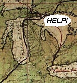
With the aid of a geographical map, Ann Althouse makes a plausible argument that Michigan's Upper Peninsula (a.k.a "da U.P." -- where the inhabitants call themselves "Yoopers") appears to have been stolen from Wisconsin by Michigan: That is ours, baby. It's like that mitten is reaching up there an yanking off our manhood. And speaking of manhood, I think, if we had that peninsula that is rightfully ours, the politics of Wisconsin might shift from Mommy Party to Daddy Party.I think it is certainly true that if Wisconsin seized the Upper Peninsula away from Michigan, the politics of the state (and possibly both states) would undergo a sea change. And it might be a good thing for the economies of both states if they agreed to have such a battle. But does the peninsula rightfully belong to Wisconsin? I think a better case could be made that the entire state of Wisconsin actually belongs to Michigan, for it was once a part of the Michigan Territory: The Territory of Michigan was an organized incorporated territory of the United States that existed from June 30, 1805, until January 26, 1837, when the final extent of the territory was admitted to the Union as the State of Michigan. Detroit was the territorial capital.Here's an early map:
The Michigan Territory only got bigger, until it engulfed and devoured Minnesota, Iowa, and nearly half of the Dakotas: In 1834, all of the lands acquired in the Louisiana Purchase that were as yet unallocated and lay east of the Missouri River (generally, the Dakotas, Iowa and the western half of Minnesota) were attached to the Michigan Territory, an area that was officially characterized as "north of Missouri and east of the Missouri and White Earth Rivers." At this point, Michigan Territory included what is now the states of Michigan, Wisconsin, Iowa, Minnesota and a large portion of the Dakotas.Just take a look at this chunk of real estate:
It was not long after that that Michigan went to war with Ohio over the Toledo Strip, but Michigan lost. President Jackson favored Ohio and in a compromise deal, it was decided to allow Michigan to become a state without the Toledo Strip but including within its new state borders the entire Upper Peninsula. Michigan became a state in 1837, shortly after Wisconsin was made a territory: Wisconsin Territory was established in 1836 with the present boundary in the Upper Peninsula.While the Wisconsin Territory did not include Michigan's Upper Peninsula, it did include the states of Minnesota, Iowa, and parts of the Dakotas. It lost them in stages until finally becoming a state in 1848: the 1836 Wisconsin Territory included all of the present-day states of Wisconsin, Minnesota, Iowa, and that part of the Dakotas that lay east of the Missouri River. The portion of the Territory east of the Mississippi River had originally been part of the Northwest Territory, which had itself been included in the cession by Britain in the 1783. Most of the remaining land of the original Wisconsin Territory was originally part of the Louisiana Purchase, though a small fraction was part of a parcel ceded by Great Britain in 1818. This land west of the Mississippi had been split off from the Missouri Territory in 1821 and attached to the Michigan Territory in 1834. In 1838, the Iowa Territory was formed, reducing the Wisconsin Territory to the boundaries for the next ten years; upon granting statehood to Wisconsin, its boundaries were once again reduced, to their present location.So, Michigan included the Upper Peninsula when it was a territory and continued to include it when it became a state in 1837. Wisconsin has a better claim to Iowa and Minnesota than it does to the Upper Peninsula. Interestingly, Michigan was not always pictured as a mitten. In older maps (like the 18th Century Mitchell Map), it looked more like a defensively angry shark, butting its snout into an Upper Peninsula which had a far more offensive overhang than it does today.
Not to sound like an apologist for a bullying, hegemonic state, but I can see why people in those days might have been led by that map to conclude that the poor shark needed to protect itself from the northern menace! posted by Eric on 06.18.10 at 05:35 PM
Comments
Hmmm... What would we call it? Yooperia? Eric Scheie · June 18, 2010 08:53 PM Upland? Anonymous · June 19, 2010 01:34 AM We could always follow Jefferson's original plan and call it "Sylvania"... http://strangemaps.wordpress.com/2008/02/25/248-friends-polypotamians-countrymen/ xj · June 20, 2010 10:14 PM We could always follow Jefferson's original plan and call it "Sylvania"... http://strangemaps.wordpress.com/2008/02/25/248-friends-polypotamians-countrymen/ xj · June 20, 2010 10:14 PM Post a comment
You may use basic HTML for formatting.
|
|
June 2010
WORLD-WIDE CALENDAR
Search the Site
E-mail
Classics To Go
Archives
June 2010
May 2010 April 2010 March 2010 February 2010 January 2010 December 2009 November 2009 October 2009 September 2009 August 2009 July 2009 June 2009 May 2009 April 2009 March 2009 February 2009 January 2009 December 2008 November 2008 October 2008 September 2008 August 2008 July 2008 June 2008 May 2008 April 2008 March 2008 February 2008 January 2008 December 2007 November 2007 October 2007 September 2007 August 2007 July 2007 June 2007 May 2007 April 2007 March 2007 February 2007 January 2007 December 2006 November 2006 October 2006 September 2006 August 2006 July 2006 June 2006 May 2006 April 2006 March 2006 February 2006 January 2006 December 2005 November 2005 October 2005 September 2005 August 2005 July 2005 June 2005 May 2005 April 2005 March 2005 February 2005 January 2005 December 2004 November 2004 October 2004 September 2004 August 2004 July 2004 June 2004 May 2004 April 2004 March 2004 February 2004 January 2004 December 2003 November 2003 October 2003 September 2003 August 2003 July 2003 June 2003 May 2003 May 2002 AB 1634 MBAPBSAAGOP Skepticism See more archives here Old (Blogspot) archives
Recent Entries
• Put The Navy In Charge
• DVD Sale • Which things are more worth dying for? • Simon • Only a hateful bigot would be intolerant of Hitler! • Jonesing • Public Morality - Private Corruption • Emasculating bullying mitten? Or oppressed and harassed shark? • Vandalism, naturally? • Making history disappear? In school?
Links
Site Credits
|
|


Why not grant statehood to the U.P.?