

|
|
|
|
January 14, 2006
Prepare to have your mind blown.
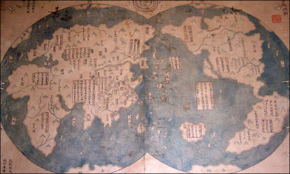
Not so fast. I'm no cartographer, and I don't study the history of Chinese exploration, but I'm not buying this map that purports to be a 1763 copy of a map drawn in the year 1418. It's believed by some to substantiate the claims made in Gavin Menzies' 1421: The Year China Discovered America. Why am I skeptical?
Who in 1418 could have sailed the seas so extensively as to map the coast lines of every major land mass on the globe, including dozens of major islands, and even antarctica? But aside from the manner of representing water, which any forger would imitate, it looks nothing at all like any Chinese maps I've been able to track down. (Cf. these, found online at the Honk Kong Baptist University.) Here's a pretty good example from 1602, which shows that chinese cartographers knew the world well enough by then. One might object that in the '1418' map California appears to be a large island, but this should be the entire west coast from the peninsula of Baja California in Mexico to Vancouver Island in Canada. In all the time it would have taken to travel that coast line, who could imagine that Alert Bay was connected to the Gulf of California? This seems like the kind of thing a forger would do, to give the impression that something was seen but not explored. But then again, what does it matter? Do you really care if an Italian didn't see America before a muslim sailor from China? How exactly does that radically alter history? Unless he yelled 'dibs.' posted by Dennis on 01.14.06 at 08:19 AM
Comments
The Europeans originally thought CA was a big island. Could be they just ripped off a period European map. That'd explain the presence of Greenland, Iceland, etc. Beck · January 16, 2006 10:42 AM Graham Hancock argues that there were even older explorers than this in a relatively interesting book Fingerprints of the Gods. I can't vouch for all of his conclusions, but at the very least he brings up some interesting stuff left over from ancient civilizations. Tom · January 16, 2006 01:31 PM (Baja) California was described as an island in the earliest maps... drawn from a Mexican perspective. This "1418" map is as bogus as those $100 bills they keep passing through North Korea. David Ross · January 16, 2006 09:52 PM |
|
March 2007
WORLD-WIDE CALENDAR
Search the Site
E-mail
Classics To Go
Archives
March 2007
February 2007 January 2007 December 2006 November 2006 October 2006 September 2006 August 2006 July 2006 June 2006 May 2006 April 2006 March 2006 February 2006 January 2006 December 2005 November 2005 October 2005 September 2005 August 2005 July 2005 June 2005 May 2005 April 2005 March 2005 February 2005 January 2005 December 2004 November 2004 October 2004 September 2004 August 2004 July 2004 June 2004 May 2004 April 2004 March 2004 February 2004 January 2004 December 2003 November 2003 October 2003 September 2003 August 2003 July 2003 June 2003 May 2003 May 2002 See more archives here Old (Blogspot) archives
Recent Entries
• War For Profit
• How trying to prevent genocide becomes genocide • I Have Not Yet Begun To Fight • Wind Boom • Isaiah Washington, victim • Hippie Shirts • A cunning exercise in liberation linguistics? • Sometimes unprincipled demagogues are better than principled activists • PETA agrees -- with me! • The high pitched squeal of small carbon footprints
Links
Site Credits
|
|
There's pretty decent evidence that Zheng He made contact with Americans, but nothing conclusive. The appearance of what looks like Easter Island and Greenland on the map should ring some alarm bells.
Personally, I find the subject fascinating, but that's probably why I'm an undergrad in History. Regardless of the Chinese or Vikings, the most significant discovery of America took place in 1492, by a guy who took along enough manpower and military technology to make a difference.